
Geo AI, short for Geospatial Artificial Intelligence, refers
to the application of artificial intelligence (AI) and machine learning
techniques to geospatial data and geographic information systems (GIS). It
combines the power of AI with location-based data to gain insights, make
predictions, and solve complex problems related to geography, mapping, and
spatial analysis.
Model the real world for prediction.
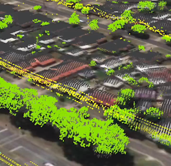
Modeling the real world for prediction using Geo AI involves
creating a digital representation of the physical world, incorporating
geospatial data, and applying artificial intelligence techniques to make
forecasts or predictions. Here's a step-by-step description of this process:
1. Data Acquisition:
- Collect
Geospatial Data: Gather various types of geospatial data from sources such as
satellites, aerial imagery, remote sensors, GPS devices, and geographic
information systems (GIS).
- Include Diverse
Data: Acquire data related to the specific problem or prediction task. This
could include terrain data, climate data, land cover data, population data,
infrastructure data, and more.
2. Data Preprocessing:
- Clean and Prepare
Data: Ensure the collected data is accurate, complete, and consistent. This may
involve removing outliers, filling in missing values, and standardizing data
formats.
- Georeferencing: Ensure all data is correctly georeferenced, meaning that it is accurately linked to specific geographic locations on Earth.
3. Feature Engineering:
- Extract Relevant
Features: Identify the features (variables) that are relevant to the prediction
task. For instance, if predicting urban growth, features might include
historical land use, population density, and proximity to transportation
networks.
- Spatial Relationships: Consider the spatial relationships between features, such as distance between points of interest or spatial autocorrelation.
4. Model Selection:
- Choose Machine
Learning Models: Select appropriate machine learning or deep learning
algorithms for the prediction task. Common models in Geo AI include decision
trees, random forests, support vector machines, convolutional neural networks
(CNNs), and recurrent neural networks (RNNs).
- Spatial Models: Consider models designed for spatial data, such as spatial autoregressive models or kriging for geostatistical interpolation.
5. Training and Validation:
- Split Data:
Divide the dataset into training and validation sets. Training data is used to
train the model, while validation data assesses its performance.
- Cross-Validation: Implement techniques like k-fold cross-validation to assess model generalization and reduce overfitting.
6. Model Training:
- Fit the model to
the training data, using the selected features as input and the target variable
(what you want to predict) as the output.
- Tune Hyperparameters: Optimize the model's hyperparameters to improve its performance.
7. Prediction and Visualization:
- Apply the trained
model to new, unseen geospatial data to make predictions or forecasts. For
example, you might predict future land use changes, weather patterns, or
traffic congestion.
- Visualize Results: Present the predictions using interactive maps, charts, or other visualizations to communicate the findings effectively.
8. Validation and Evaluation:
- Evaluate Model
Accuracy: Use appropriate metrics (e.g., Mean Absolute Error, Root Mean Square
Error, R-squared) to assess the accuracy and reliability of predictions.
- Validate against Real-World Data: Compare model predictions to real-world observations to validate its effectiveness.
9. Iterate and Refine:
- Continuously refine the model by incorporating new data, improving features, or adjusting model parameters.
10. Deployment:
- If the model performs well, consider deploying it in real-world applications to support decision-making, such as urban planning, disaster management, resource allocation, or environmental monitoring.
By following this process, Geo AI can help create predictive
models that provide valuable insights and support decision-making in various
real-world scenarios.
Geospatial Artificial
Intelligence (Geo AI) plays a crucial role in supporting decision-making for
urban planning and development. Here are several ways in which Geo AI can
assist in these areas:
1Data Analysis and
Visualization: Geo AI can process and analyze large volumes of geospatial data,
including satellite imagery, aerial photographs, and geographic information
system (GIS) data. It can then create interactive maps and visualizations that provide
valuable insights into urban environments, such as land use, transportation
networks, and population density.
2. Site Selection: When
planning new infrastructure projects or developments, Geo AI can help identify
suitable locations based on various factors like accessibility, environmental
impact, and land availability. It can also consider historical data and future
projections to make informed recommendations.
3. Environmental Impact
Assessment: Geo AI can assess the potential environmental impact of urban
development projects. It can model scenarios to predict how changes in land use
or construction will affect ecosystems, air quality, and water resources, allowing
decision-makers to make environmentally responsible choices.
4. Traffic and
Transportation Planning: Geo AI can analyze traffic patterns and congestion in
urban areas. It can optimize transportation routes, suggest improvements to
public transportation systems, and predict future traffic conditions to help
alleviate congestion.
5. Risk Assessment: Geo
AI can assess the vulnerability of urban areas to natural disasters such as
floods, earthquakes, and wildfires. This information is vital for planning
resilient cities and mitigating risks through proper zoning and infrastructure development.
6. Urban Growth
Prediction: By analyzing historical data and using machine learning models, Geo
AI can predict urban growth trends. This information is essential for long-term
urban planning, helping cities prepare for increased population and infrastructure
demands.
7. Real-Time Monitoring:
Geo AI can provide real-time monitoring of urban environments, including air
quality, noise levels, and temperature. This data can inform immediate
decision-making and policy adjustments.
8. Community Engagement:
Geo AI can facilitate public engagement by providing accessible and interactive
maps that allow citizens to participate in the planning process. It can gather
feedback, identify community concerns, and help create more inclusive urban
development plans.
9. Infrastructure
Maintenance: Geo AI can assist in the maintenance of urban infrastructure by
monitoring the condition of roads, bridges, and buildings. It can predict when
maintenance is needed, helping cities allocate resources efficiently.
10. Regulatory
Compliance: Geo AI can ensure that urban development projects comply with
zoning regulations and environmental laws. It can flag potential violations and
streamline the permitting process.
11. Cost Optimization: By
analyzing data and simulating different scenarios, Geo AI can help urban
planners and developers optimize costs associated with infrastructure projects.
This includes budgeting, resource allocation, and cost-benefit analysis.
In summary, Geo AI
empowers decision-makers in urban planning and development by
providing data-driven insights, enabling more informed and sustainable choices,
and improving the overall quality of life in cities.
Tags
GEO AI
Geographic Information
Systems (GIS)
Location Intelligence
Spatial Analysis
Remote Sensing
Geospatial Data
Artificial Intelligence
in Geography
GIS Applications
Geospatial Technology
Geographic Information
Science
Satellite Imagery
Geospatial Analytics
Location-Based Services
Geospatial Machine
Learning
Geospatial Data
Visualization
GeoAI Benefits
Importance of GeoAI
GeoAI in Business
GIS for Environmental
Management
GIS in Urban Planning
Precision Agriculture
with GeoAI
Disaster Management with
GeoAI
Future of GeoAI
Geospatial Trends
Spatial Data Integration


No comments:
Post a Comment